Week 7: Reviews of DH GIS Sites
Pleiades
Pleiades is a crowdsourced gazetteer and graph of ancient (read Mediterranean) place names. It is intended for both humans and computers, allowing search by key word or API and data exports available as JSON, CSV, KML, and RDF files.
Although crowd-sourced, it is meant to be an authoritative collection of geographic information about the ancient world. Each place name includes references (and links where available) to original and secondary sources in which it is mentioned. Like Wikipedia, each contribution is documented and open to all to review, annotate, edit, and update; every change is documented; and every contributor credited. This project demonstrates that crowdsourcing and authority need not be mutually exclusive models of knowledge management.
The platform takes advantage of the RDF modeling language to give each place a unique URI (uniform resource identifier) that enables the aggregation of all name changes and spelling variations and GIS coordinates. RDF also allows connections to other place names (e.g., Carsulae is a Roman town along the Via Flaminia), going beyond just plotting places on a map.
Pleiades describes itself as an “un-GIS” because it “distinguishes between place and space.” That is, while GIS technologies like ArcGIS plot coordinates on a map, they do not and cannot encompass the concept of place - Rome as a concept not a map coordinate. This is especially useful for ancient places where the precise geographic location of the place is not known or only known generally in relation to other places.
The locations are displayed Mapbox and Leaflet JS. The project began in 2006 and has been continuously updated since, demonstrating lasting usefulness, accessibility, and credibility.
City Witness: Medieval Swansea
The Medieval Swansea project attempts to depict medieval Swansea based on descriptions found in a 14th century Vatican manuscript. The manuscript includes the Rashomon testimonies of several who witnessed the events surrounding the 1290 hanging of a man who was brought back to life.
There are virtual tours intended for the general public and a game aimed at children. A visitor can go on a virtual walking tour of medieval Swansea by clicking on waypoint numbers overlaid on a modern day map, but only six sites are plotted on the modern map. A visitor can also take a tour of each witness story with sight-lines but rather primitive visualizations. The aim of the project is to explore place and perspective from the different literal and figurative vantage points of the witnesses.
The project was built in 2014, using OpenStreetMap tiles and Leaflet JS. It was produced by academics for the general public (worst of both worlds?). Overall, the site was gimmicky and required too many clicks to get at meaningful information.
I found the Context and Mapping sections to be far more informative than the virtual tours. This material was more scholarly. The mapping process (described here) combined narrative descriptions and plotted these locations on a map so you can get a sense of the locations of the buildings in relation to one and other and the landscape. This was useful as an example of what the technology can do, but did not convince me that the GIS exercise added to existing scholarship about this historical episode.
John Smith’s Voyages
In 1608, John Smith made two voyages exploring the Chesapeake Bay. In 1612, he created a remarkably accurate map of the Chesapeake Bay, his travels up its tributaries, and the tribes he encountered along the way: 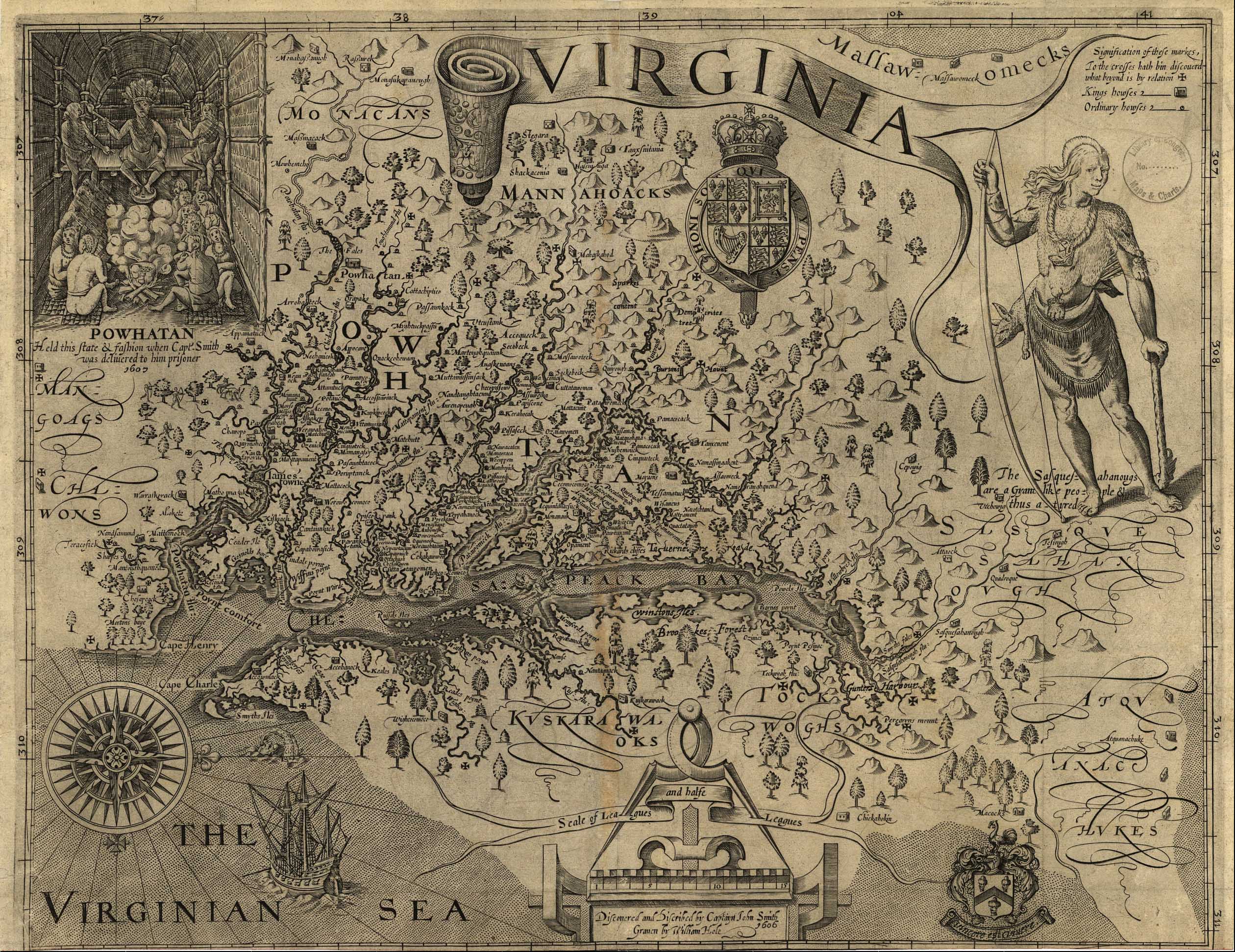 image courtesy of NPS
Virtual Jamestown, created by the Virginia Center for Digital History, overlays this map onto modern towns and geographic places. The project is old, built in conjunction with the 400th anniversary of his voyages in 2007, and as a result, is visually unpleasant and clunky. It uses Flash player to plot each day of the voyage as taken from Smiht’s log. It may have been revolutionary at its time, but now appears stale.
A similar endeavor was undertaken by the Sultana Project (here). This version is more visually appealing and has more information. However, the resulting maps are too small. The Sultana Project is a non-profit organization devoted to preservation and education about the maritime history of the Chesapeake. Some might say this makes it less “scholarly.” The Sultana Project site is much more detailed and informative than the one produced by the Virginia Center for Digital History at the University of Virginia. Its scholarship is evident in its methods and results, not in the professional titles of its creators.